Ride Large


The Oaxaca Triangle
-
Total Time: 2 days
-
Total Distance: 336 miles (540)
-
Total time on two wheels: 14.5 hrs
-
Day One
-
Distance: 136 miles (218 km)
-
Time on two wheels: 6 hrs
-
-
Day Two
-
Distance: 200 miles (322 km)
-
Time on two wheels: 8.5 hrs
-
The Route


Day 1
-
Distance: 136 miles (218 km)
-
Time on two wheels: 6 hrs
The Directions
Pretty simple — The route begins in Oaxaca de Juarez — Take the 175 through the mountains until you hit San Juan Bautista Tuxtepec
The Road
A lot of traffic coming out of Oaxaca, but it quickly fades as you begin to climb — In general, the road is decent with stretches of nice pavement and stretches of potholes
The Weather
I've ridden this route several times and have seen it in all kinds of conditions
Most days have been clear and sunny with beautiful views of the valleys, farms, and mountains — Normal protection and a light underlayer worked fine
I have ridden it once during a rainy day — Be prepared for cold weather and fog riding
About 4.5 hours in you will hit San Juan Bautista Valle Nacional — From here on out the weather will likely be very hot and humid — Keep hydrated
The Elevation
Starting in Oaxaca at about 5500 feet, you climb to about 10,000 in the Sierra Madre Mountains and then drop down to sea level in San Juan Bautista Valle Nacional
Where to Eat
A little restaurant called "Paraíso Los Encinos Restaurente" — Local food specific to this little part of Oaxaca
Arguably the best food I have eaten in Mexico
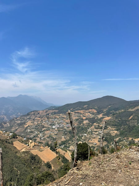
The Scenery
Begin with beautiful views of Oaxaca de Juarez as you rise into the mountains, and then several hours of smooth roads, mountains, and farms
Day 2
-
Distance: 200 miles (322 km)
-
Time on two wheels: 8.5 hrs
Directions
Two Part route here
Part one is 5 hours from San Juan Bautista Tuxtepec on highway 182 to Teotitlán de Flores Magón
Part two is 4 hours on highways 980 and 150 from Teotitlán de Flores Magón through Puebla and then into Veracruz
There is an optional 4.5 hr route from Teotitlán de Flores Magón to Orizaba that takes you back through the mountains — Disclaimer, I have not take this route yet
The Road
Not the best road leading out of San Juan Bautista, especially around the Lake Miguel Alemán region, but the road begins to get better as you pass San Felipe Jalapa de Díaz and begin to climb into the mountains
The road Part 2 is basically normal highway
The Weather
San Juan Bautista Tuxtepec is hotter than hell and is more humid than Houston, but the weather cools off as you climb into the mountains
Once you drop back down into Teotitlán de Flores Magón, the weather is again hotter than hell, but much drier
Be careful riding into Puebla, as the wind blows very hard
The Elevation
Starting at Sea Level, you climb to about 6500 feet through the mountains before dropping to about 3300 feet as you reeenter El Valle de Oaxaca
From there you ride through the high plains before dropping down into Orizaba
Where to Eat
I did not eat on this ride, but there is a forgotten Pueblo Magico called Huautla de Jiménez that I sure has some good food — Ask the locals for the best restaurant in town and they will tell you
The Scenery
Stunning views of the Sierra Madre with striking cliffs and valleys
As you drop back down to Teotitlán de Flores Magón, you get possibly the most stunning view of the Valle de Oaxaca I have yet to see
Random Videos


Random Images